A Mountain Is Not Just a Peak: Teaching Physical Geography Through Evidence and Landforms
When an elementary student draws a mountain on paper, the result is almost always a jagged, isolated triangular peak capped with a small triangle of white snow. Introducing young geographers to a well-sequenced mountain ranges workbook for kids is the most effective way to replace that cartoon triangle with genuine earth systems science. This hands-on mountain ranges workbook for kids guides learners to discover that a mountain range is not a single pointy summit, but a vast interconnected landscape of uplifted ridges, descending slopes, carve-out valleys, and essential waterways.
Standard classroom printables often reinforce what geologists call the «peak trap». Worksheets typically list the highest elevations above sea level, prompting children to memorize summit heights like Everest or Denali as isolated trivia. This approach hides the real dynamic story: height above sea level merely tells us how high a place sits above the ocean, whereas local rise reveals how dramatically high ground actually towers over its surrounding terrain. A broad plateau might sit 3,800 meters above sea level while rising only 100 meters above its neighbors, while a steep 1,500-meter ridge can plunge 1,000 meters down into a sheer valley.

In Earth & People: Mountain Ranges Around the World — More Than Tall Peaks (a 30-page printable workbook designed for ages 7–10), young scientists investigate these highland terrains through five dedicated scientific lenses: Rise (how mountains are built), Shape (what reshapes rock and land), Height (what changes as you climb), Water (where the water goes), and Change (what changes over time).

Topographic Contours and Tectonic Architecture
To understand physical landforms, young learners must bridge the gap between flat two-dimensional maps and three-dimensional terrain.
On the «Top View, Side View» spread, students investigate topographic contour lines:
- Each closed contour line connects points situated at identical elevations above sea level.
- When contour rings are bunched tightly together, the slope is precipitous and steep.
- When contour lines spread broadly apart, the terrain rises gently.
Children match top-down contour maps directly to side-view elevation cross-sections, learning how to visualize three-dimensional landforms on flat paper.
From there, the workbook explores how these structures are born. Students examine three distinct geological building processes: tectonic folding where colliding plates compress rock into immense waves, fault-block movement where crustal blocks tilt along fracture lines, and volcanic buildup where successive layers of molten lava and ash pile onto older rock.

The Himalayan Fossil Mystery: Deep Time and Uplift
One of the most striking evidentiary puzzles in elementary geology appears on page 8: Why are fossilized ocean shells discovered thousands of meters high in the Himalayan peaks?
Instead of simply stating that mountains grow, the workbook guides children through a four-stage forensic sequence:
- Ancient marine organisms die, and their shells settle into soft seafloor sediment.
- Over millions of years, compacting sediment slowly hardens into solid sedimentary rock.
- Crushing tectonic collisions between Earth’s crustal plates fold, buckle, and lift those rock strata miles above the ocean.
- Later weathering and glacial erosion expose the ancient sea fossil high along a mountain ridge.

This deductive rock analysis teaches children to read strata as historical records. In the same way that young paleontologists evaluate sedimentary layers and fossil anatomy to reconstruct prehistoric ecosystems in our Dinosaur Workbook for Kids, geology students realize that high mountain crags preserve tangible proof of ancient, vanished environments.
Furthermore, mountains do not just grow indefinitely. Through a clever mathematical model called the «Mountain Budget,» students calculate net elevation changes: $\text{Finish Height} = \text{Start} + \text{Uplift} — \text{Erosion}$. Children discover that if tectonic uplift pushes rock upward by 4 units while rain, ice, and landslides strip away 4 units, the surface height remains completely unchanged even though the rock continues to rise and churn.
Glaciers, Continental Divides, and Living Altitudinal Zones
High peaks act as Earth’s natural water towers, storing winter precipitation and sorting continental river basins:
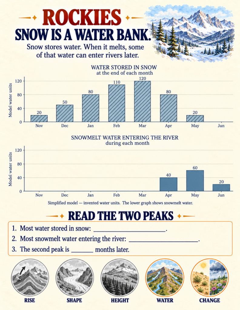
- The Snowpack Water Bank: In the Rocky Mountains case file, students analyze monthly water storage graphs. They observe that peak snow storage occurs in March (120 units), while maximum snowmelt surging into downstream rivers peaks two months later in May (60 units), illustrating how high mountain snowpacks function as seasonal water reservoirs for lower valleys.
- Continental Divides: Children trace falling raindrops near the Colorado Continental Divide, discovering that high ridgelines act as natural hydrological boundaries, diverting water either west into the Colorado River and the Pacific basin, or east into the Mississippi-Missouri network and the Atlantic.
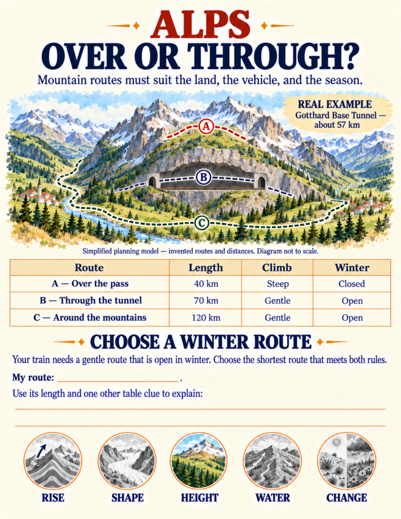
- Glacial Valley Carving: In the Alps, students analyze field clues—broad flat floors, sheer vertical walls, parallel striations, and hanging waterfalls—to recognize the signature U-shaped cross-section carved exclusively by grinding glacial ice, contrasting it with the narrow V-shaped gorges cut by running rivers.
[IMAGE INSERT]
As students climb upward through these mountain environments, they witness dramatic environmental gradients.
On the tropical Andes climbing trail, children observe air temperatures dropping from $22^\circ\text{C}$ in the dense foothill forests at 1,000 meters to a chilling $4^\circ\text{C}$ among alpine grasses at 4,000 meters.
This altitudinal succession directly governs plant life. In our Plant Life Cycle Workbook, children investigate how temperature and moisture dictate seed germination and leaf transpiration; along high mountain slopes, students observe this botanical limit firsthand, watching tall broadleaf trees give way to stunted cloud forests and low, hardy cushions adapted to freezing winds.
These extreme vertical belts also dictate animal survival. Studying how wildlife develops specialized physiological and behavioral adaptations to survive thin mountain air, steep rock screes, and freezing winters connects seamlessly with our Animal Life Cycles Workbook, where students examine how organisms adapt their developmental stages to survive environmental pressures.
Finally, the physical barrier of a mountain range dramatically alters continental weather patterns. As moist ocean winds slam into mountain barriers, rising air cools and drops heavy rain on coastal slopes, creating lush forest biomes—similar to the moisture-rich canopies detailed in our Tropical Rainforest Workbook—while leaving the inland side in an arid rain shadow.
Practical Implementation for Home and Classroom
Because Mountain Ranges Around the World is self-contained with clear diagrammatic keys, scaffolded evidence cards, and complete solution guides, it adapts cleanly to various teaching routines:
- Homeschool Physical Geography Block: Complete two pages daily over three weeks for a comprehensive, screen-free earth science unit covering plate tectonics, cartography, and hydrology.
- Small-Group Detective Stations: Set up laminated copies of the «Mystery Range Detective» (page 23) where students eliminate candidates using height, collision folding, and modern glacier data.
- Capstone STEM Cartography Project: The final «Build a Mountain Field Map» mission (page 26) asks students to draft their own imaginary mountain chain, placing tectonic divides, downhill river paths, altitudinal vegetation zones, and glacial valley profiles onto a single unified landscape.
If you are looking for an educational printable that replaces passive summit coloring with authentic topographic literacy, structural geological reasoning, and hydrological modeling, Mountain Ranges Around the World provides your young explorer with an engaging, structured expedition through Earth’s most dynamic landscapes.