The Fastest Vehicle Doesn’t Always Win: Teaching Logistics, Networks, and Systems Thinking
Ask an elementary student how to travel between two distant cities as quickly as possible, and they will almost always blurt out the same answer: take an airplane. Finding an authentic journey planner workbook for kids that dismantles this speed illusion is essential for cultivating genuine systems thinking. This applied journey planner workbook for kids guides young learners to realize that a vehicle in motion is only one single link in a larger chain, and that arriving at a hub is never the same thing as being ready to depart.
Standard elementary social studies printables rarely challenge the «fastest vehicle trap». Worksheets typically present transport as an isolated choice: an airplane flies fast, a train runs moderately fast, and a car drives slowly. Children are left assuming that the vehicle with the highest top speed guarantees the earliest arrival. They overlook the hidden links: driving to the out-of-town airport, passing through security, waiting at the gate, claiming baggage, and catching secondary ground transport to the actual doorstep.

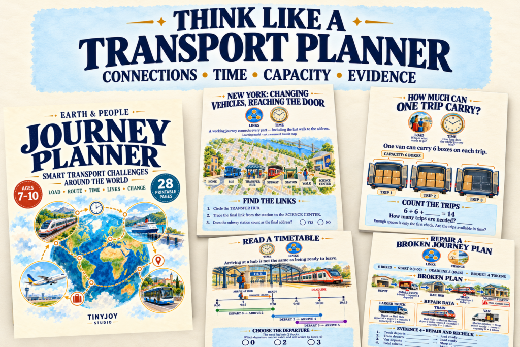
In Earth & People: Journey Planner — Smart Transport Challenges Around the World (a 28-page printable workbook designed for ages 7–10), young strategists evaluate journeys through five distinct analytical lenses: Load (who or what needs to go), Route (which way to go and what stands in the way), Time (how long the whole chain takes), Links (where vehicles and hubs connect), and Change (what happens when weather, capacity, or timetables shift).

Counting the Whole Chain: Escaping the Speed Trap
Real-world logistics begins when children stop looking at vehicle velocity and start calculating the total door-to-door timeline.
On the spread titled «The Fastest-Vehicle Trap,» students evaluate two trips heading to the exact same destination using uniform 15-minute time blocks:
- The Airplane Option: 4 blocks to reach the airport, 6 blocks to wait and clear security, 4 blocks of flight, 2 blocks for baggage collection, and 2 blocks to drive to the final address ($4 + 6 + 4 + 2 + 2 = 18\text{ blocks}$).
- The Train Option: 2 blocks to reach the downtown station, 1 block waiting on the platform, 12 blocks riding the rails, and 1 block walking to the address ($2 + 1 + 12 + 1 = 16\text{ blocks}$).
Even though the airplane moves through the air three times faster than the train rolls along the tracks, the complete train chain arrives half an hour earlier. Children discover that transport is a sequence of handoffs: if a transit link does not deposit cargo or passengers directly at the destination door, additional connecting links must be funded and scheduled.
This systems-level logic mirrors how energy and fluids circulate through living organisms. Just as botanical organisms require uninterrupted internal vascular pipelines to move water from subterranean roots all the way to high leaf canopies—mechanisms explored in our Plant Life Cycle Workbook—a successful journey requires every transfer point to connect seamlessly without broken gaps.

Physical Barriers and Multimodal Engineering
As young planners travel across the workbook’s case studies, they analyze how planetary landforms dictate infrastructure choices:
- Water Gaps (Norway): Deep coastal fjords split highway networks, requiring roll-on roll-off ferries or multi-kilometer undersea road tunnels like Ryfast to bridge the gap.
- Steep Mountain Slopes (La Paz, Bolivia): Winding roads up sheer valley walls create severe switchback traffic, making the aerial cable cars of Mi Teleférico a vastly more direct transit link.
- Canal Elevation Changes (Panama): When ships cross between oceans, rising terrain requires freshwater locks fed by inland lakes to step vessels up and down.
- Monsoon Delta Waterways (Bangladesh): Seasonal rivers submerge roads, turning waterways into the primary transit highway for passengers and supply cargo.
Investigating these regional adaptations demonstrates that civil infrastructure is shaped by the physical geography of our planet. When children examine how human settlements navigate severe terrain constraints, coastal ports, and inland trade routes—as detailed in our Countries and Capitals Workbook—they see why historic cities and transport arteries were strategically built around navigable rivers and mountain gaps.

Managing Deadlines, Budgets, and Vehicle Capacity
Logistics is never just about finding a route on a map; it requires balancing capacity, departure schedules, and finite budgets.
In the workbook’s middle section, students tackle operational friction:
- The Transfer Lag: On page 16, children evaluate train timetables. Arriving at a transit station at 9:15 AM (Block 1) with a required 1-block transfer handling time means a passenger is not ready to depart until 9:30 AM (Block 2), completely missing the 9:00 AM departure and forcing a careful recalculation to meet a 10:00 AM deadline.
- Capacity vs. Return Trips: When moving 10 cargo crates with a strict 2-block deadline, children discover that using a small van (capacity 8) requires two delivery trips and an empty return trip ($1 + 1 + 1 = 3\text{ blocks}$), violating the deadline. They must upgrade to a larger van (capacity 12) that completes the job in a single run.
Understanding how multiple moving parts interact within tight mathematical constraints shares deep parallels with orbital mechanics. Just as planetary trajectories, gravity assists, and launch windows require exact timing—principles examined in our guide to the Solar System Explorer Workbook—dispatching freight across multimodal links demands strict synchronization.
Seasonal Shifts and Climate Disruption
A functioning transit plan is never permanent. In northern Manitoba, Canada, temporary winter ice roads allow heavy supply trucks to reach remote communities across frozen muskeg and lakes. When spring thaws arrive, the road disappears, forcing planners to evaluate air freight alternatives, seasonal barge services, and payload limits.
These environmental dependencies highlight how ecological cycles regulate human systems. Much like the global atmospheric and moisture cycles explored in our Festivals Around the World Workbook, where community gatherings and harvest celebrations follow celestial and agricultural calendars, logistics networks must adapt dynamically when seasonal weather alters physical routes.
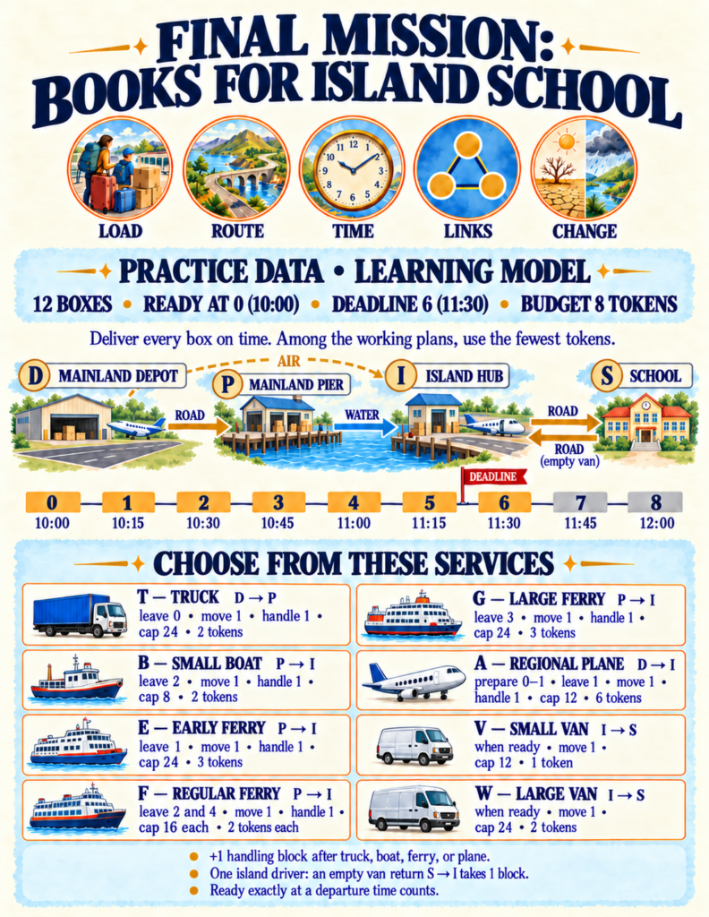
The workbook culminates in a multi-page simulation: The Island School Mission. Students must deliver 12 supply boxes from a mainland depot across open water to an island school before a strict 11:30 AM deadline (Tick 6) while staying within an 8-token budget. They analyze trucks, early ferries, regular ferries, cargo barges, and island delivery vans.
Just as they master the optimal 5-token route, the load changes to 20 boxes. Rather than starting over, children audit their system, hold cargo during intermediate handling blocks, scale up to higher-capacity ferries, and defend their revised plan with evidence.
Practical Integration for Home and Classroom
Because Journey Planner is completely self-contained with visual route maps, simulated timetables, and a complete answer key, it requires zero specialized preparation:
- Homeschool Applied STEM Unit: Complete two pages daily over two to three weeks for an applied unit blending social studies, math, and network engineering.
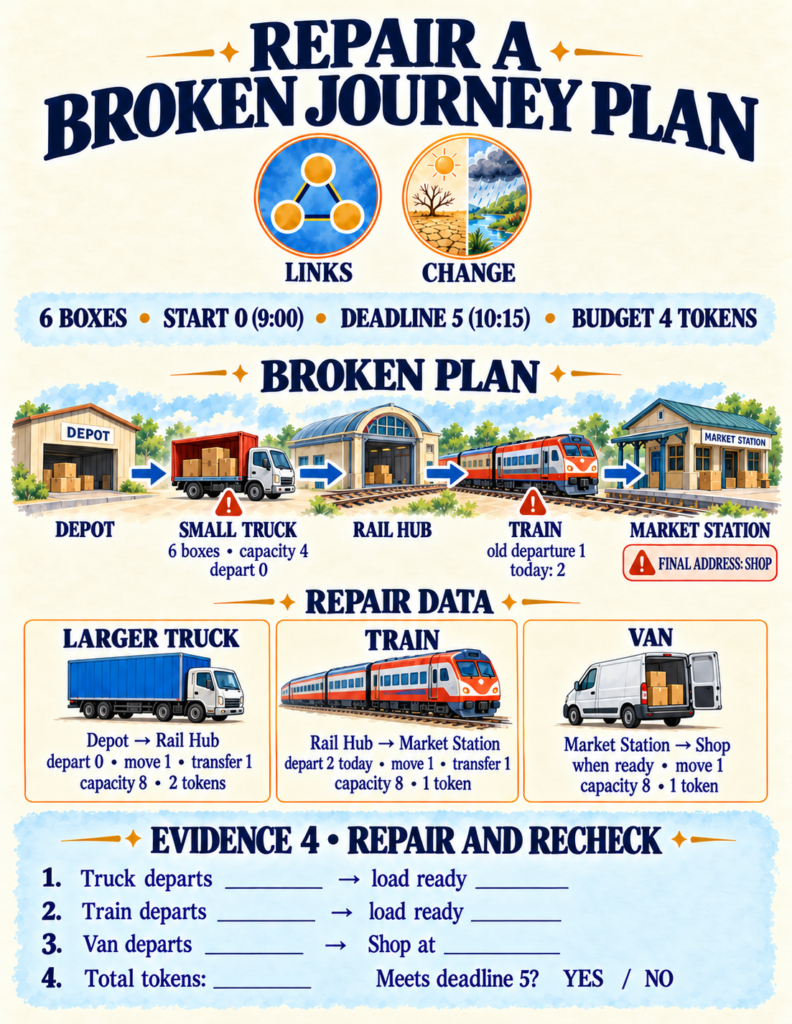
- Logistics Inquiry Stations: Print the «Mystery Route Detective» and «Repair a Broken Journey Plan» spreads for small-group collaborative problem-solving.
- Screen-Free Critical Thinking: Use the five core lenses (Load, Route, Time, Links, Change) as an ongoing family framework when planning real road trips, bus commutes, or flight layovers.
If you are looking for an educational printable that trades passive vehicle naming for authentic logistical reasoning, route optimization, and systems thinking, Journey Planner provides your young explorer with a practical toolkit for understanding how our mobile world connects.